Wednesday 22 June 2022

The Ochil Hills from Menstrie, Clackmannanshire

(Revised 22nd July 2022 to include additional photos)

The Ochil Hills (or Ochils for short) stretch approximately 25 miles between Stirling and Perth in Central Scotland. They offer tremendous walking opportunities, from wonderful hill climbs to magical, rocky glens to easier walks along forest tracks. This lesser known walk, follows part of the track that runs from Menstrie in Clackmannanshire, to Sheriffmuir Rd to the north, in the county of Stirling. The main photos are taken from our most recent visit this month.

The route climbs steadily and depending on your pace / fitness, it will serve as a good workout. The walk takes us along a wide and very easy to follow forest track. The views are great and it's also fine to walk if it's been raining. There's one short section that you can skirt around the edge of, if it happens to be muddy. There are muddy pools off to the side of the path at times however and if your dog is like Jasper, you can expect them to get pretty muddy!

I usually let my dogs off the lead on this hill path, except when on the rare occasion I have come across the odd stray sheep (usually near the bottom of the hill at the start), so do keep your eyes peeled. There are also the occasional rocky crags to be aware of, particularly if your dog is prone to going a wandering and does not have good recall. Keep an eye out for the occasional mountain biker too.

The walk is a there and back route covering 1.74 miles each way (3.48 miles in total). There is a free car park at the start of the route. Maps, further location info and GPX file are included at the end of the article. All the images in the article can be clicked / tapped to enlarge them.

Our walk begins at the Dumyat Community Centre car park in Menstrie. Exit the car park and cross over to the Hollytree pub. Take the turning just to the left of the pub (Park Road). A little way up Park Road, you will see the Midtown Gardens park on the left hand side. A short detour across the grass here will take you to the "Fox Boy" sculpture by acclaimed artist Andy Scott. Andy Scott is the creator of the incredible Kelpies horses sculpture near Falkirk. I'll write an article about the Kelpies at some point in the future. Close to "Fox Boy" you will also find a World War I / II Memorial.

"Fox Boy" by Andy Scott. Decorated in Pride colours. Click / tap to enlarge picture.

World War I / II Memorial

Continue to the top of Park Road and turn right along Ochil Road. A short way along the road you will pass a row of terraced cottages on the left hand side. Turn left up the lane between the houses, just after the cottages. Go through the gate at the top of the lane and onward up the forest track.

The snaking track climbs through the hills into Jerah Woodland and along the slopes of Menstrie Glen. It's a straightforward route to follow along the main track. As you climb, the panoramic views across the Forth Valley are ever present as a backdrop.

Looking back down the initial section of the path that zigzags its way up the hill

There are lots of paths off the main track which vary in terms of gradient and difficulty, some leading to parts of the hills where you will find cattle or sheep. The hill to the right is Myreton and serves as a popular spot for paragliding.

To the left, across the glen, you will see Dumyat (pronounced Dum-Eye-At). Dumyat is a very popular hill to climb and it affords fantastic views from the top. It's another walk I will cover at a later date. The easiest route is from the far side of the hill over at Sheriffmuir; the routes from this side are much steeper.

In the distance, to the left of Dumyat, you will see the National Wallace Monument poking up from its perch on Abbey Craig. As the name suggests, it's a monument to Sir William Wallace (the protagonist of the rather historically inaccurate film "Braveheart"). To the left and further behind the Wallace Monument, lies Stirling, with its castle sitting above it.

Jasper and Tommy with Dumyat hill in the background

View across Forth Valley with Broomhall Castle hotel and the sprawling warehouses of drinks giant Diageo

View of Menstrie and Forth Valley

Further into the hills

Looking back towards Dumyat with the National Wallace Monument and Stirling in the distance

Our walk ends at a metal gate that crosses the path. You can continue through the gate to follow the path further if desired. The path continues to meander its way further through the hills for approximately 3.7 miles, before coming out on Sheriffmuir Road.

The gate that marks the end of our walk

Beyond the gate, the path continues through the hills

Here are a few of my favourite pictures taken when we've walked this route previously:

Taken in May 2021, there is plenty of gorse around (or whin as it's known as here). A dramatic sky sits above Dumyat.

Somewhere beneath that fog lies the Forth Valley (Dec 2021).

The National Wallace Monument and Stirling Castle floating in the fog behind Dumyat, like islands in the sky (Dec 2021).

The view west across the hills, towards the snow capped Trossachs (Dec 2021).

The sun setting over Dumyat with a dusting of snow, like icing sugar. Jasper looks on, probably contemplating which scent trail to follow next! (Jan 2021)

Route overview with surrounding hills in context (click / tap to enlarge)

Route detail - section 1 of 2

Route detail - section 2 of 2

Link to start location on Google Maps


PLEASE BE SURE TO READ OUR DISCLAIMER WHICH ALSO INCLUDES IMPORTANT SAFETY INFORMATION.

Wednesday 15 June 2022

Crail and Kilminning Coast Wildlife Reserve, East Neuk of Fife

Earlier this month, we visited Crail in the East Neuk of Fife and walked along the Fife Coastal Path to the wildlife reserve at Kilminning. It was a beautiful day; warm but at around 16°C, so not too hot for the dogs. We do get sunshine in Scotland sometimes! The walk also afforded a number of opportunities for the dogs to have a splash in the sea and cool off.

The walk out is 2.5 miles and the return leg 1.8 miles (4.3 miles in total). You'll find toilet facilities at Crail Harbour and at Roome Bay. Maps, further location info and GPX file are included at the end of the article. All the images in the article can be clicked / tapped to enlarge them.

We parked up just off the main drag in Crail (Marketgate). Crail is a picturesque and historic fishing village, with a particularly attractive harbour. It's one of these places where locals take pride in their quaint properties and there are plentiful displays of colourful flowers. We walked through the village passing the Mercat (market) cross, parts of which date from the 17th century. Then onto the High Street and Westgate, passing galleries, cafes and souvenir shops along the way, before turning left down the lovely cobbled, though steep, Hen's Ladder.

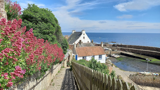
"Hen's Ladder and Crail Harbour" (click / tap to enlarge)

Hen's Ladder comes out at the harbour, where we pass some attractive white washed properties and the distinctive "Lobster Cottage", adorned with two lobsters around the window of its little attic room. The cottage dates back to the 1630s! To the left of the cottage is the late 17th century Customs House; note the fishing boat displayed above the gates, which you can also see in the picture below.

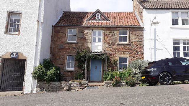
"Lobster Cottage, Crail Harbour"

The harbour has plenty of picnic benches and is a great place to stop for an ice cream. There's also a shack selling fresh lobster. We didn't find any doggie ice cream for Jasper and Tommy but I must admit they did get a little vanilla instead!
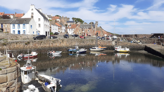
"Crail Harbour"

Leaving the harbour, our route ascends to Castle Walk and out along the coast.

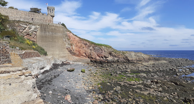
"View of Castle Walk from the harbour"

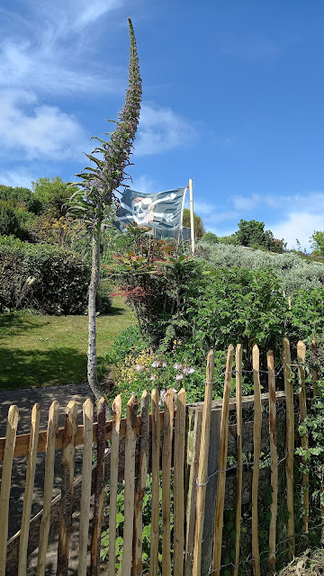
"We passed a garden with a Jolly Roger flying in it"

Along much of our route, the Isle of May can be seen off the coast, in the distance. It's a nature reserve where you'll find puffins and seals. There are boat trips to the island from Anstruther (further south along the coast) but dogs are not permitted.

"Looking out towards the Isle of May" (click / tap image for larger photo)

We pass the site of an old mill (Kings Mill) and on to a wide grassy area at Roome Bay. You will also see the distinctive white 16th century Priory Doocot (dovecote) on the left. We continue on towards Sauchope Links Holiday Park.

"Tommy having a rest at a water stop for the dogs"

"Coastal path towards Sauchope Links Holiday Park"

Our route goes through the extensive holiday park. Be aware of cars when walking through it as it can be quite busy. We then continue onwards into Kilminning Coast Wildlife Reserve. Rare plants grow on the grasslands and wetlands here. It's also a haven for birds and dolphins can apparently be spotted offshore sometimes.

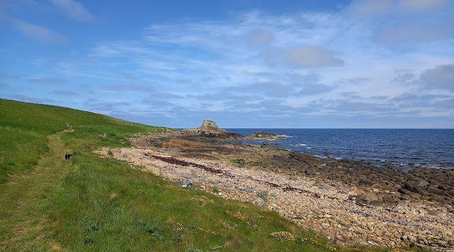
"Approach to the nature reserve"

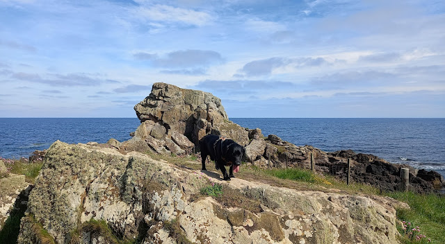
"Jasper guarding a rock"

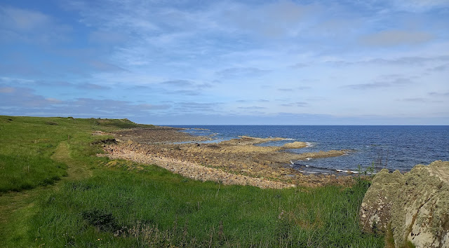
"Kilminning Coast Wildlife Reserve"

Our outward walk ends just before the historic Crail Golfing Society course. The Kilminning Wildlife Reserve car park is nearby, thus affording us the opportunity to continue further along the coastal path from this point in the future. If you decide to venture further, be aware of golfers as you'll be walking across the trajectory of their golf balls at times. This applies both at the Crail course and at the other golf course further along at Kingsbarns. As for us, we retraced our steps back along our route, cutting back up to the car past the Priory Doocot.

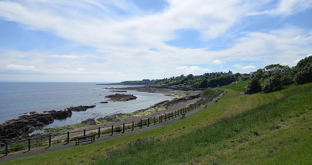
"View back towards Crail"

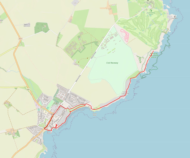
Route overview (click / tap to enlarge)

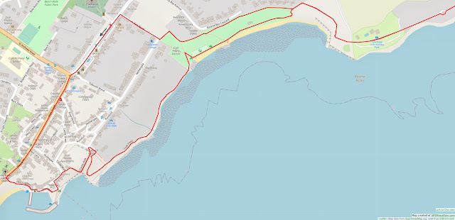
Route detail - section 1 of 3 (direction of route shown by arrow and start/end of route just before arrow)

Route detail - section 2 of 3

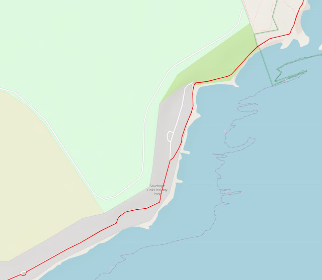
Route detail - section 3 of 3


PLEASE BE SURE TO READ OUR DISCLAIMER WHICH ALSO INCLUDES IMPORTANT SAFETY INFORMATION.

Popular Posts